What is the Dai-Nihon Enkai Yochi Zenzu?
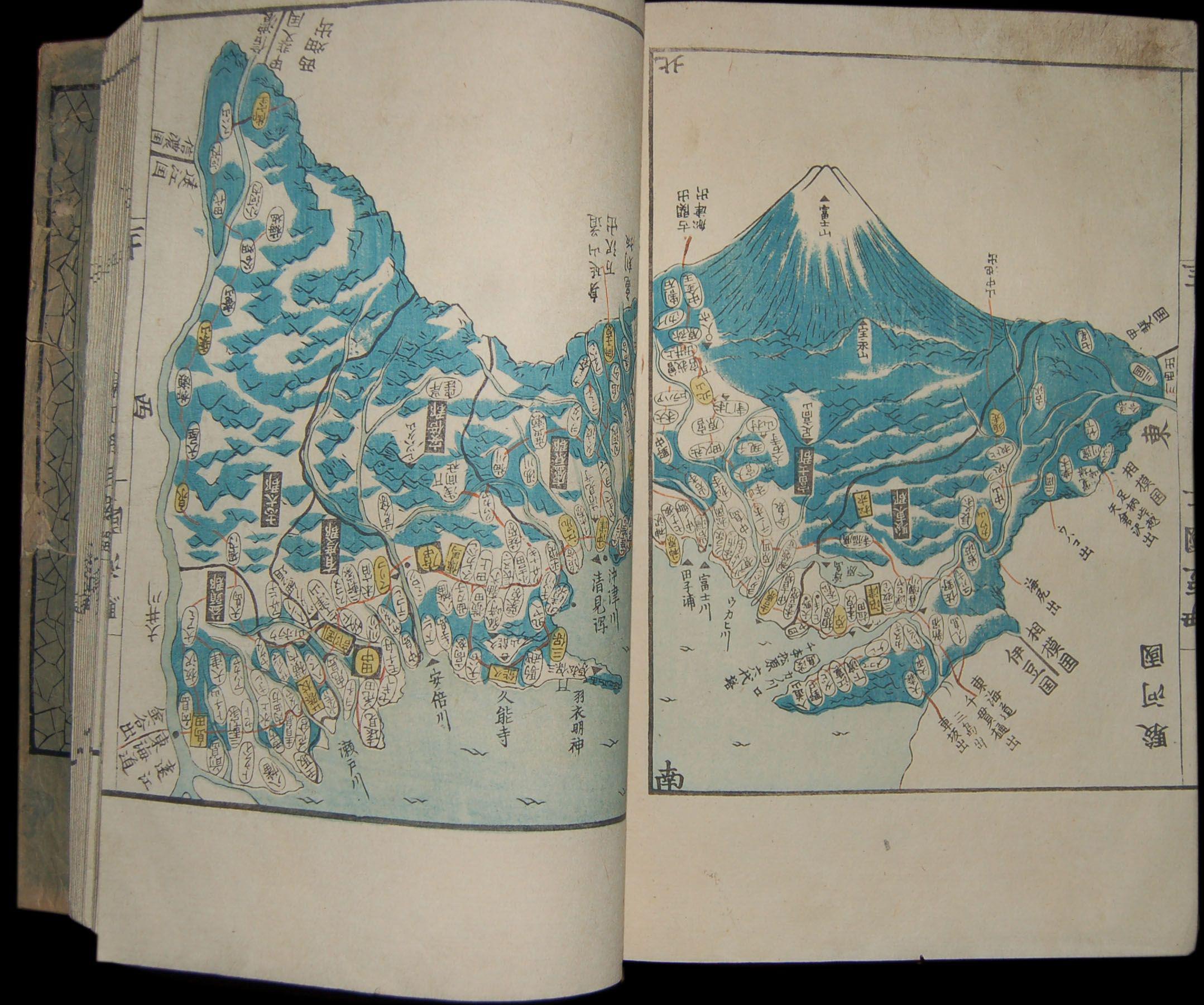
Detail from the Dai-Nihon Enkai Yochi Zenzu. Coastlines, place names, and survey measurements are recorded with density that reflects the 17 years of fieldwork behind them. Source: Wikimedia Commons — detail from the 1838 woodblock Ino Tadataka atlas
The name looks difficult, but what it’s saying is simple. The Dai-Nihon Enkai Yochi Zenzu (大日本沿海輿地全図) is the formal name of the nationwide map of Japan completed in 1821, based on Ino Tadataka’s surveys and finished by his disciples after his death. Most people call it the Ino Map (Inō-zu).
But leaving it at “formal name of the Ino Map” misses how dense this object’s story actually is.
The name, broken into four parts
| Part | Reading | Meaning |
|---|---|---|
| 大日本 | Dai-Nihon | All of Japan |
| 沿海 | Enkai | The coast, the shoreline |
| 輿地 | Yochi | Land, geography |
| 全図 | Zenzu | A complete map |
The name is essentially its own description: “a complete map of all the land and coast of Japan.” Long, but direct.
If you want to play with the coastline idea first, try Ino Tadataka Stepper. It is a short browser game where a surveyor moves along Japan’s shore as you tap left and right.
The scale of the map: 225 sheets across three types
The Dai-Nihon Enkai Yochi Zenzu is not a single sheet. It is an atlas of 225 maps at three different scales.
| Type | Scale | Sheets | What it shows |
|---|---|---|---|
| Large map (daizu) | 1/36,000 | 214 | Detailed coastlines, place names, survey measurements. Finer than a modern 1/25,000 topographic map |
| Medium map (chūzu) | 1/216,000 | 8 | Regional overview |
| Small map (shōzu) | 1/432,000 | 3 | The whole country in three sheets |
The 214 large-scale sheets are where most of the survey data lives. They connect edge-to-edge to cover the entire Japanese coastline without a gap. A single daizu sheet is roughly equivalent to two or three modern topographic map sheets.
How it was finished — and why Ino never saw it
According to the Geospatial Information Authority of Japan, Ino carried out ten major surveys from 1800 to 1816, then died in 1818 while the editing work was still ongoing.
His death was kept quiet for a time so the editing could continue uninterrupted. His disciples, led by Takahashi Kageyasu (son of Ino’s own teacher), brought the work to completion. In 1821, the Dai-Nihon Enkai Yochi Zenzu was completed and formally presented to the shogunate — three years after Ino’s death.
The map is not the work of one person. It is a project that Ino centered on, but that his successors carried across the finish line.
The originals are gone — destroyed twice, then found in Washington
The map’s history after completion is one of repeated loss.
1868 (Meiji Restoration): The copy presented to the Tokugawa shogunate was destroyed in a fire at the imperial palace.
1923 (Great Kantō Earthquake): The Ino family’s copy, held at Tokyo Imperial University, was destroyed in the earthquake and resulting fires.
By the mid-20th century, fewer than about 60 large-scale sheets were known to survive within Japan — mostly partial copies held by daimyo houses or Meiji-era reproductions.
2001: A survey of the U.S. Library of Congress identified 207 sheets of the Ino Map, of which 148 had been completely unknown to Japanese researchers. They had been acquired by a foreign visitor during the late Edo or early Meiji period and kept in Washington ever since. This single discovery made it possible, for the first time, to study the map as a near-complete work.
In 2021, a map held by the Zenrin Museum in Japan was newly authenticated as an alternate copy of the small-scale Ino Map — another piece of the puzzle still turning up two centuries later.
Why it remains important
The Dai-Nihon Enkai Yochi Zenzu is not famous simply because it is old.
As a technical achievement: Producing 214 large-scale sheets at 1/36,000 required that distance, bearing, and latitude measurements all be internally consistent across the entire country. That level of integration was new for Japan in 1821.
As a historical document: The Meiji government used the Ino Map as a reference for early infrastructure planning, including railway routes. Japan’s modern mapping work traces directly back to this project.
As a story: A map completed by disciples after their teacher’s death, with its originals destroyed twice by disaster, and its most complete surviving copy sitting undiscovered for 150 years in a Washington library. The object itself has a narrative that doesn’t end in 1821.
Quick questions
What is the Dai-Nihon Enkai Yochi Zenzu?
The formal name of the nationwide map of Japan completed in 1821, based on Ino Tadataka’s surveying work. 214 large-scale sheets (1/36,000), 8 medium (1/216,000), and 3 small (1/432,000), totaling 225 sheets. Commonly called the Ino Map.
What are the three scale types?
Large map: 1/36,000, 214 sheets. Medium map: 1/216,000, 8 sheets. Small map: 1/432,000, 3 sheets.
Where are the originals?
The shogunate copy was destroyed in the 1868 palace fire. The Ino family’s copy was lost in the 1923 Great Kantō Earthquake. The largest surviving collection — 207 sheets — was found at the U.S. Library of Congress in 2001.
Are the “Ino Map” and “Dai-Nihon Enkai Yochi Zenzu” the same?
Essentially yes. “Ino Map” is the popular name; the Dai-Nihon Enkai Yochi Zenzu is its formal title and definitive completed form.
Related reading
- How Did Ino Tadataka Survey? Pacing, Bearings, and the Sky
- Ino Tadataka’s Surveying Tools: The Equipment Behind 40,000 Kilometers
- Ino Tadataka Stepper — tap along Japan’s coastline
- Why Is Ino Tadataka Famous? A Simple Guide to the Man Who Mapped Japan After 55
- Who Was Ino Tadataka? The Edo Surveyor Who Restarted His Life at 50
- Ino Tadataka Timeline: From 1745 to the 1821 Ino Map in Five Periods
- Ino Tadataka’s Teacher and Disciples: The Network Behind the Ino Map
- Footscroll — walk with Ino Tadataka
References
- Geospatial Information Authority of Japan: Ino Tadataka
- Geospatial Information Authority of Japan: Old Map Collection — the Ino Maps
- Geospatial Information Authority of Japan: Special Exhibition on the Ino Maps
Footscroll
Walk Ino Tadataka's Journey With Your Own Steps
Footscroll turns your daily step count into a quiet journey across a washi-style map of Japan, inspired by Ino Tadataka's survey routes.