Knowing the tools makes the method make sense
Ino Tadataka’s surveys didn’t run on willpower alone. Distance tools, direction tools, reference-point tools, and sky-observation tools each handled a different part of the job, and together they turned 40,000 kilometers of walking into a map.
| Job | Main tools | What it gave the map |
|---|---|---|
| Measure distance | Pacing / ryōteisha wheel | How far you’ve traveled |
| Record direction | Staff compass / semicircular azimuth board | Which way each line runs |
| Mark stations | Bonten pole | A target visible from a distance |
| Correct position | Quadrant / meridian scope | Latitude fix to reset accumulated error |
Distance ①: pacing — 69 cm per step, 17 years running
Where pacing’s accuracy came from
Ino is famous for pacing — measuring distance by walking with a calibrated stride — but the accuracy wasn’t an accident. He trained his stride length deliberately from an early age and kept it at about 69 cm per step. With a consistent stride, 10,000 steps equals roughly 6.9 km.
In the field, the same stretch was often walked in both directions and the two readings compared, which filtered out single-trip counting errors. Pacing wasn’t crude — it was a managed technique for turning distance into numbers under early-1800s field conditions.
Distance ②: the ryōteisha wheel — counting rotations on flat roads
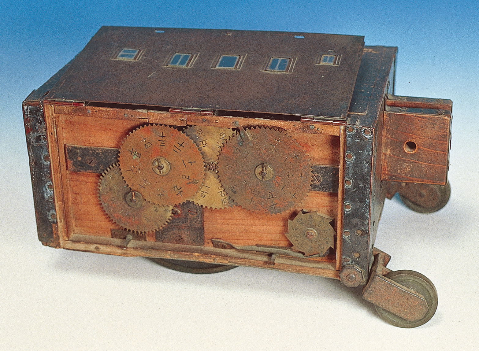
Ryōteisha (National Treasure), 1566 × 1148 px original. The wheel’s circumference was a fixed design value; an internal gear accumulated rotations and displayed total distance on a dial. Functionally similar to a mechanical odometer. Source: Katori City, Ino Tadataka Memorial Museum — image archive
The ryōteisha supplemented pacing on flat, rollable roads. Because the wheel’s circumference was a known value, every full rotation added exactly one circumference to the total. A crew member read the dial at each station.
The constraint: it only works where the wheel can roll. Steep slopes, sandy beaches, and narrow mountain paths all required falling back on pacing. The practical rule was: use the wheel on good roads, use pacing everywhere else.
Direction ①: the tsuesaki staff compass — fast bearings at every station
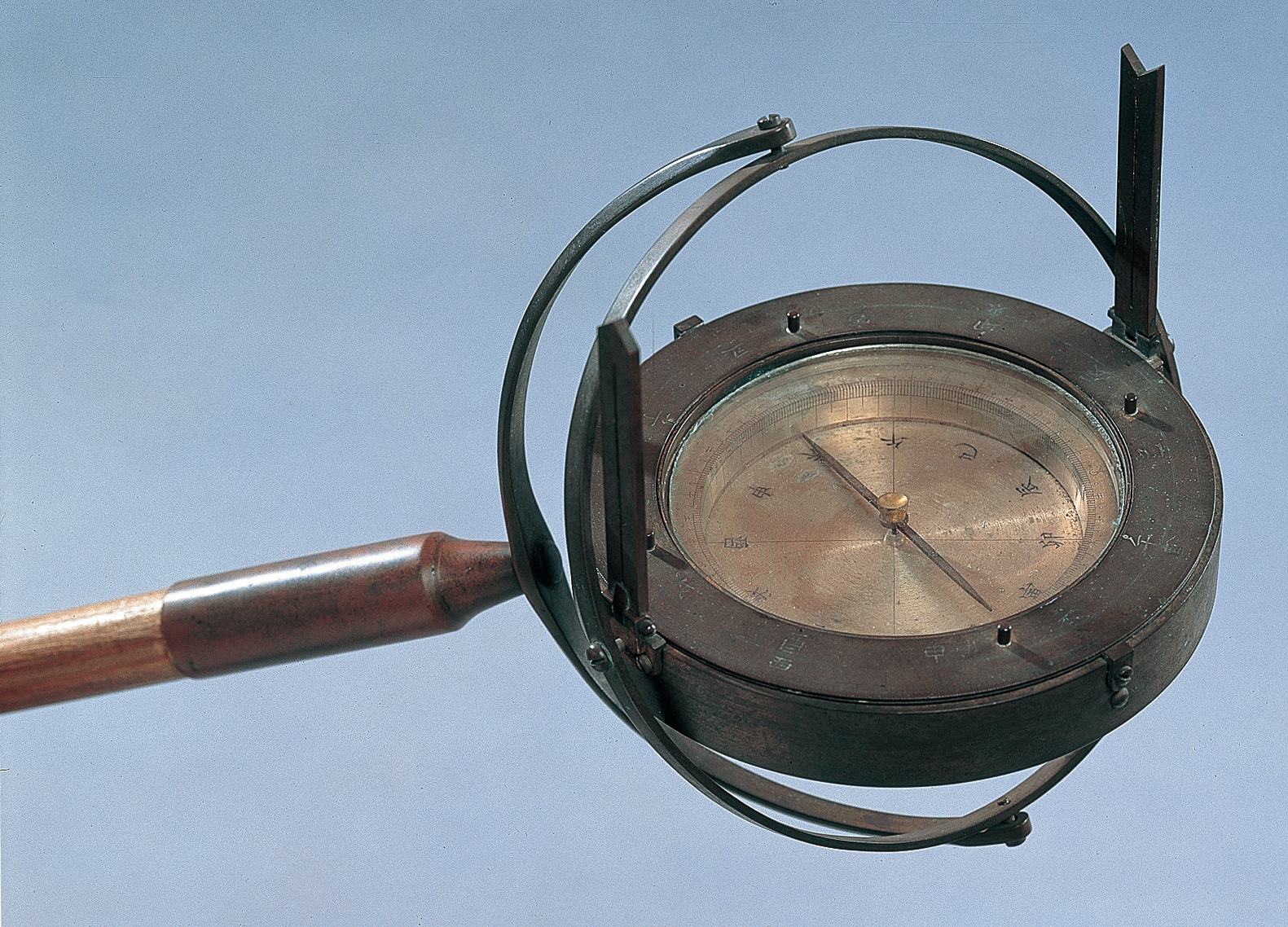
Tsuesaki staff compass (National Treasure), 1581 × 1138 px original. Mounted on a staff tip for portability; the staff is planted at the survey station, the needle settles, and the bearing is read directly from the graduated ring. Source: Katori City, Ino Tadataka Memorial Museum — image archive
The tsuesaki staff compass was, according to the Katori City museum records, one of the instruments used most frequently throughout the surveys. The workflow was simple: arrive at a station, plant the staff, wait for the needle to settle, read the bearing angle, record it. Do this at every station across 40,000 km.
This continuous stream of (distance, bearing) pairs is what gave the survey records their map-convertible structure. Without direction at each point, the data stays a travel log.
Direction ②: the hanmaru semicircular azimuth board — reading distant peaks and islands
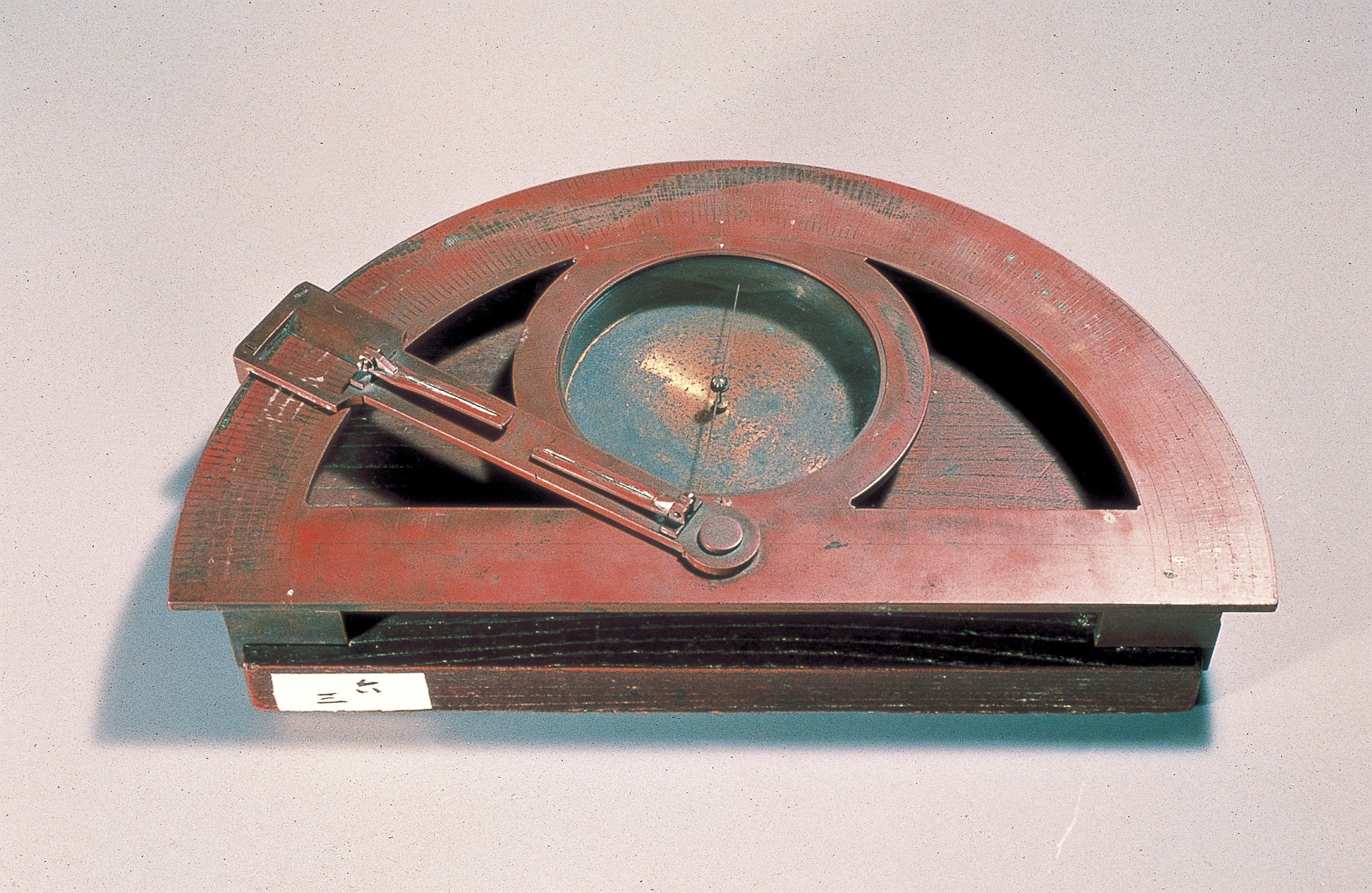
Hanmaru semicircular azimuth board (National Treasure), 2292 × 1491 px original. A half-circle graduated scale with a sighting arm and magnetic needle. More finely divided than the staff compass; used to measure the bearing to a distant mountain summit, cape, or island. Source: Katori City, Ino Tadataka Memorial Museum — image archive
Where the staff compass handled routine route bearings, the hanmaru semicircular azimuth board was deployed for distant targets — a mountain summit visible across a bay, an island offshore, a cape several kilometers away.
By measuring the bearing to the same landmark from two different survey stations, the team could triangulate the landmark’s position. This cross-checking between ground-level route data and distant landmark sightings is part of how the Ino Map achieved its coastal accuracy.
Reference points: the bonten pole — making the next station visible
The bonten was a long staff with a white paper ornament at the top, planted at the forward survey station while bearings were taken from behind.
The reason it existed is straightforward: you can’t aim a compass at a point you can’t see. In open terrain, the next station might be 300–500 meters ahead. The bonten’s white ornament was visible at that distance, giving the bearing reader a specific target to align with.
Low-tech, easy to miss in a list of instruments — but without a visible reference point, every bearing reading becomes an approximation.
Latitude: the shōgengi quadrant — resetting position from the sky

Shōgengi quadrant (National Treasure), 1663 × 2604 px original (portrait orientation). Fan-shaped (90°) angle plate with a sighting arm and plumb bob. The arm is aimed at Polaris; the plumb bob indicates the angle from vertical, which equals the observer’s latitude. Source: Katori City, Ino Tadataka Memorial Museum — image archive
The shōgengi is where Ino’s survey stops being “a very careful long walk” and becomes something more systematic.
The principle: the altitude of Polaris above the horizon equals the observer’s latitude (at latitude 35°N, Polaris sits about 35° above the horizon). Point the quadrant’s sighting arm at Polaris, read the plumb bob’s angle — that’s your latitude.
Why does this matter? Because pacing and bearing measurements drift. Over hundreds of kilometers, small errors compound. The quadrant provides an absolute positional fix from outside the ground-based system, allowing the accumulated drift to be corrected at intervals.
According to the Geospatial Information Authority of Japan, Ino studied under astronomer Takahashi Yoshitoki specifically to master this kind of sky-based position verification. It was built into the method from the start, not added as an afterthought.
The shigogi meridian scope
Alongside the quadrant, Ino used a shigogi (meridian scope) to observe the exact moment a star crossed the meridian — the north-south line directly overhead. The precise transit time enabled longitude corrections to complement the quadrant’s latitude readings. Latitude from the quadrant, longitude from the meridian scope: together they fixed an absolute position for each major observation site.
All four roles, working together
Remove any one of the four tool categories and the chain breaks:
| Remove this | What breaks |
|---|---|
| Distance tools | No numbers on how far each segment ran |
| Direction tools | No way to know which way the segments pointed |
| Bonten | Bearings become estimates, not measurements |
| Quadrant | Error accumulates unchecked across the whole country |
Keeping all four running, consistently, across 17 years of fieldwork — that’s the real story behind the 40,000-kilometer number.
Quick questions
What tools did he use?
Distance: pacing and the ryōteisha wheel. Direction: tsuesaki staff compass (routine bearings) and hanmaru semicircular azimuth board (distant landmarks). Reference points: bonten pole. Latitude correction: shōgengi quadrant and shigogi meridian scope.
What was the ryōteisha?
A wheel-based distance counter; the wheel’s circumference was a fixed design value, and an internal gear accumulated rotations into a total distance reading. Used on flat roads alongside pacing.
What was the bonten?
A long staff with a white paper ornament, planted at the forward survey station. It gave the bearing-reader a visible target to aim at, which is necessary for accurate compass readings at distance.
Why was the quadrant needed?
Pacing and bearing measurements accumulate small errors over long distances. The quadrant measured Polaris’s altitude (= latitude) to provide an absolute positional fix from the sky, letting the team correct the ground survey’s drift at intervals.
Related reading
- Who Was Ino Tadataka? The Edo Surveyor Who Restarted His Life at 50
- How Did Ino Tadataka Survey? Pacing, Bearings, and the Sky
- How Far Did Ino Tadataka Walk? Unpacking the 40,000-Kilometer Number
- What Is the Dai-Nihon Enkai Yochi Zenzu? The Formal Name of the Ino Map, Explained
- Footscroll — walk with Ino Tadataka
References
- Geospatial Information Authority of Japan: Ino Tadataka
- Geospatial Information Authority of Japan: Old Map Collection — the Ino Maps
- Katori City, Ino Tadataka Memorial Museum — image archive
Footscroll
Walk Ino Tadataka's Journey With Your Own Steps
Footscroll turns your daily step count into a quiet journey across a washi-style map of Japan, inspired by Ino Tadataka's survey routes.