A Map Is Not Accurate in Only One Way
The Ino Map is often described as astonishingly accurate for the Edo period. That is fair. But if we ask, “Was it more accurate than world maps of the same era?”, the answer needs more care.
Accuracy can mean several things:
- how closely a coastline or road was traced
- how well the whole country was fixed within a geodetic framework
- how accurately latitude and longitude were determined
- whether the map projection worked across a wide area
The Ino Map was not equally strong in all of these. It had clear strengths and clear limits. The interesting part is that it was good enough to compare with major contemporary mapping projects, while being built in a different way.

The Short Version
The Ino Map was not a national triangulation map in the same sense as the Cassini Map of France or early Ordnance Survey mapping in Britain.
Its core was open-traverse surveying: moving from point to point, measuring distance and direction, and accumulating those lines along coasts and roads. Ino Tadataka’s teams then used intersection observations and astronomical observations to check and correct the results.
Are Intersection and Triangulation the Same?
This is the easy place to get fuzzy. Intersection and triangulation are not the same thing, though they use related triangular geometry.
Intersection means observing the same distant target, such as a mountain, island, cape, or tower, from multiple known survey points. The crossing bearing lines help locate the target or reveal drift in the measured route. In Ino’s survey, intersection worked as a check on open traverses.
Triangulation, in the Cassini Map or Ordnance Survey sense, starts from a carefully measured baseline and chains triangles together to build the framework of a whole country. That is not just a check; it is the map’s geodetic skeleton.

That makes the comparison look like this:
| Map or survey | Main framework | Strength | Limitation |
|---|---|---|---|
| Ino Map | Open traverses + intersection + astronomy | Detailed surveyed coastlines and roads; latitude correction | Longitude and large-area projection |
| Cassini Map, France | Geodetic triangulation network | National skeleton and road network | Not equally precise for houses, wetlands, or forest boundaries |
| Ordnance Survey, Britain | Baselines + precision theodolites + triangulation | Control-point network for national mapping | Early map publication progressed region by region |
| Contemporary navigation | Celestial observation + almanacs + chronometers | Position at sea through latitude and longitude | Longitude depended on accurate timekeeping |
So the Ino Map should not be treated as a direct winner or loser. It belongs to a different engineering choice: trace the coastline in detail on the ground, then use the sky to control accumulated error.
Ino’s Method: Ground Lines Checked by Intersections and the Sky
Ino’s survey measured distance and direction on the ground. Distances were recorded by pacing, ropes or chains, and distance wheels; directions were read with compasses and azimuth boards.
The problem is that open traverses accumulate error. Even small errors in each segment become serious when they are connected across thousands of kilometers.
Intersection observations helped first. From points along the measured route, the team could observe the bearings to distant mountains, islands, capes, or other visible targets. If the bearing lines failed to converge naturally on the target, that suggested drift in distance or direction.
Astronomical observation then added another layer. If intersection checked the route against visible ground targets, star observations tightened the north-south position from outside the ground network.
Michio Nogami’s research explains that Ino used astronomical observations at 1,220 sites to correct the north-south coordinate values derived from surface surveying. In simpler terms: the field survey created the lines, and the stars helped correct their latitude-like position.
The Ino Map was therefore not merely “a map made by walking.” It was a map made by walking the lines, checking them with intersection observations, and using astronomy to tighten the north-south position.
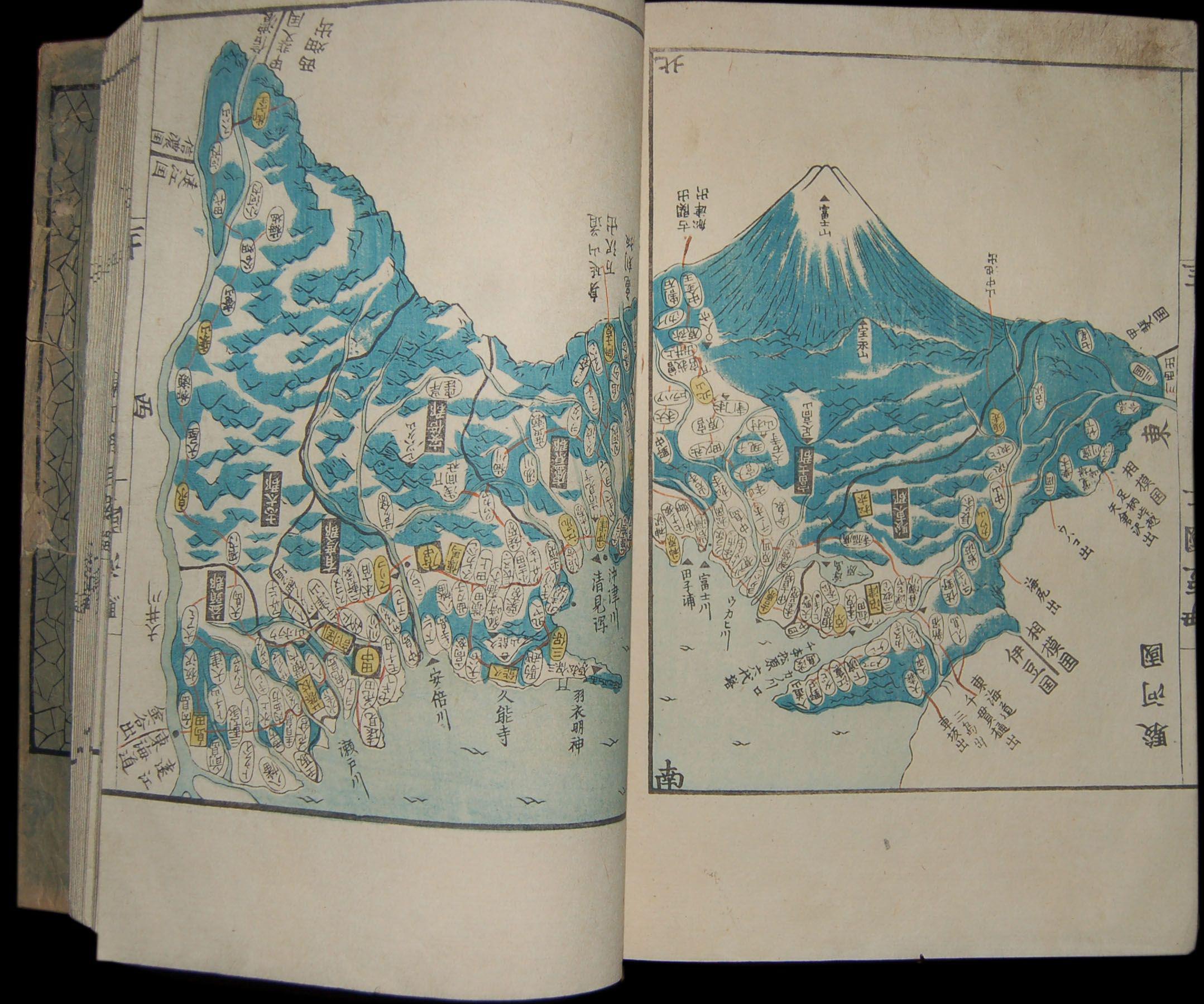
Detail from an Ino map. Source: GSI Old Map Collection: Ino Maps
The Longitude Problem
The Ino Map’s main technical limit was longitude.
Latitude can be found from the altitude of the Sun or stars. Longitude is harder because it requires accurate time comparison between places. That was not only a Japanese problem; it was one of the great problems of ocean navigation.
Britannica explains the same divide in the history of navigation: latitude could be determined from celestial altitude, while longitude remained difficult until marine chronometers and nautical almanacs made accurate time-based methods practical.
Ino’s teams attempted longitude-related observations, but without practical portable chronometers, they could not directly correct east-west coordinates in the same way they corrected north-south values.
This is why the Ino Map can be impressive in coastline shape and latitude control, while still showing east-west displacement at broad scale.

The Cassini Map: France by Triangulation
The most useful comparison is the Cassini Map of France.
The Cassini Map was made in the 18th century and completed in publication by 1815. It used a scale of 1:86,400 and was built on geodetic triangulation. A French departmental archive describes it as a decisive technical advance and the first map to use geodetic triangulation.
Compared with the Ino Map:
| Point | Ino Map | Cassini Map |
|---|---|---|
| Main subject | Japanese coasts and main roads | The Kingdom of France |
| Main method | Open traverse, intersection, astronomy | Geodetic triangulation |
| Scale | Large map 1:36,000; medium 1:216,000; small 1:432,000 | 1:86,400 |
| Strong point | Dense ground measurement along surveyed lines | National triangulation framework |
| Caution | Longitude correction was limited | Not every landscape detail was equally precise |
The Cassini Map was closer to the modern geodetic state map: establish a triangulated skeleton, then build the map on it.
The Ino Map had a different strength: detailed ground traversal along the lines actually walked and measured.
For copyright and reuse reasons, this article does not reproduce Cassini map images directly. You can view the map through France’s Géoportail.
To compare the maps directly, view the Ino maps through the GSI Old Map Collection and the Cassini map through Géoportail: Carte de Cassini. This article embeds only existing local images and original diagrams where reuse is clear.
Britain and the Rise of National Triangulation
Britain’s Ordnance Survey also developed around triangulation.
Ordnance Survey describes William Roy’s late-18th-century work connecting the Greenwich and Paris observatories, using a measured baseline and Ramsden’s great theodolite. In 1791, the purchase of another Ramsden theodolite became the recognized birth of Ordnance Survey.
This was the same broader direction as the Cassini project: use precision angle measurement, baselines, and trigonometry to create a national control framework.
Ino’s work did not follow that exact model. It was not weak because of that; it was solving a different problem with different institutional and technical conditions. But if the question is “which project was closer to modern geodesy?”, the answer is the triangulation-based European national surveys.
If the question is “who traced a huge coastline in exceptional detail through field measurement?”, Ino becomes much more important.
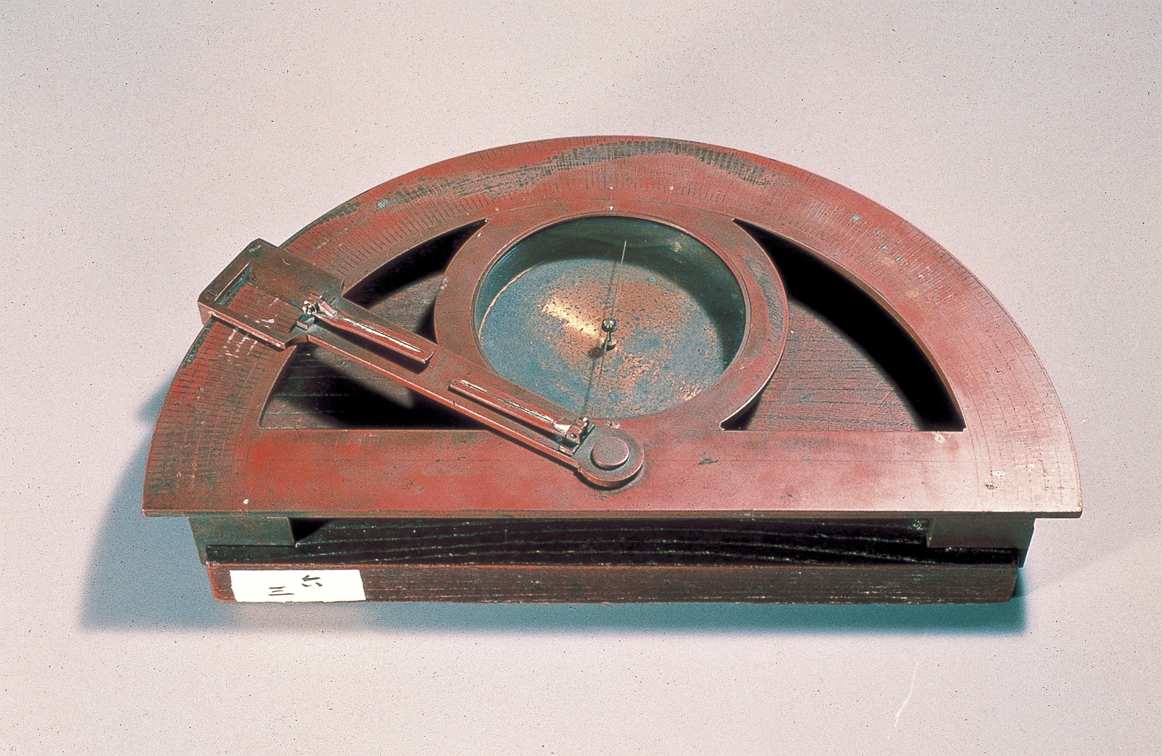
Instruments and Methods
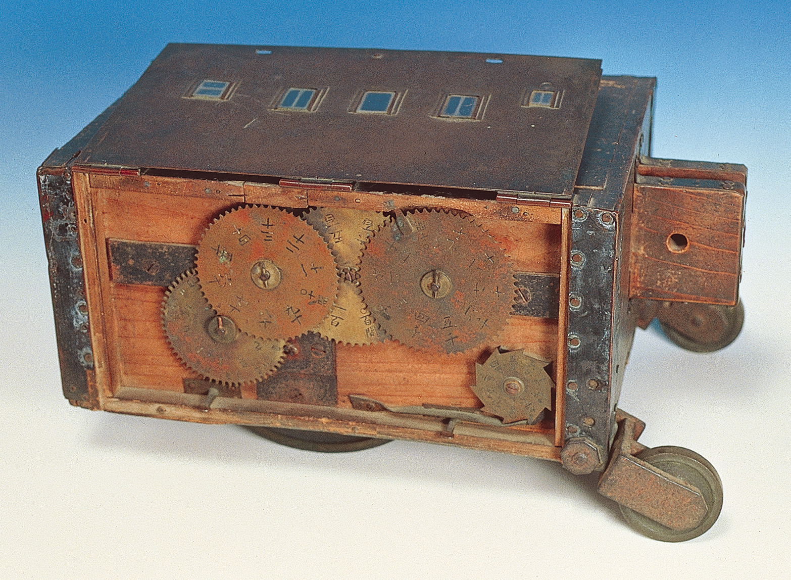
Counted wheel rotations to accumulate distance on roads where it could roll.
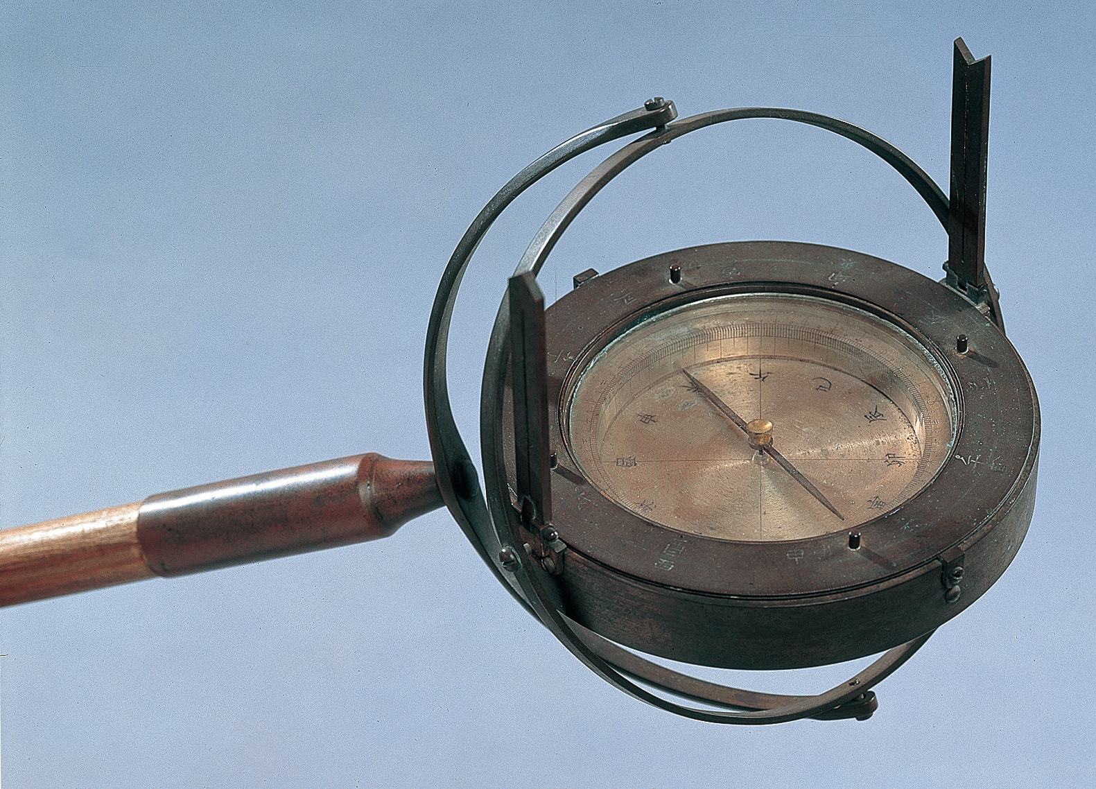
Recorded the bearing from one survey point to the next.
Measured bearings to distant mountains, capes, and islands.

Measured celestial altitude for astronomical latitude checks.
Instrument image source: Katori City, Ino Tadataka Memorial Museum image archive
| Method or instrument | What it measured | In Ino’s survey | In contemporary world surveying |
|---|---|---|---|
| Pacing | Distance | Used especially in earlier surveys and difficult terrain | Common simple field method |
| Rope or chain | Distance | Measured point-to-point distances | Basic surveying equipment |
| Distance wheel | Distance | Useful on roads where a wheel could roll | Similar odometer-like ideas existed elsewhere |
| Compass / azimuth board | Direction | Recorded bearings along routes and to targets | Angle measurement was central to surveying |
| Quadrant / meridian instruments | Celestial altitude and meridian passage | Used for astronomical latitude control | Important in navigation and geodesy |
| Theodolite | Horizontal and vertical angles | Not the main Ino instrument | Central to British and French triangulation |
| Chronometer | Accurate time | Not practically available to Ino’s teams | Became crucial for longitude at sea |
Ino’s distinction was not the invention of one new instrument. It was the long-term operation of distance measurement, direction recording, and astronomical correction across an enormous field project.
So How Accurate Was It?
Compared with the most advanced European national surveys, the Ino Map was behind in one major respect: it was not based on a countrywide geodetic triangulation network.
But compared as a field survey of coastlines and routes, supported by astronomical latitude correction, it was highly impressive. It belongs in the same historical conversation as the Cassini Map and Ordnance Survey because all of them show the same broader transformation: maps becoming measured systems rather than inherited pictures.
The fairest summary is:
The Ino Map was not the world’s most advanced triangulation map. But as a nationwide map built from open traverses and astronomical correction, it was precise enough to stand beside the major mapping achievements of its age.
That is more interesting than simple praise. It places Ino Tadataka in a global moment when mapmaking was becoming scientific, practical, and state-scale.
Related Articles
- How Accurate Was the Ino Map? Reading It as an Edo-Period Achievement
- How Did Ino Tadataka Survey? Pacing, Bearings, and the Sky
- Ino Tadataka’s Surveying Tools: The Equipment Behind 40,000 Kilometers
- What Is the Dai-Nihon Enkai Yochi Zenzu? The Formal Name of the Ino Map, Explained
- Footscroll — walk with Ino Tadataka
References
- Geospatial Information Authority of Japan: Ino Tadataka
- National Diet Library: Surveying Methods
- J-STAGE: Surveying Method and Mapmaking Techniques of INO Tadataka
- J-STAGE: Star Observation Correction in the Mapmaking Process of Ino Tadataka
- Archives départementales de la Creuse: Carte de Cassini
- Ordnance Survey: OS history
- Ordnance Survey: An OS history of the theodolite
- Britannica: Longitude measurements
Footscroll
Walk Ino Tadataka's Journey With Your Own Steps
Footscroll turns your daily step count into a quiet journey across a washi-style map of Japan, inspired by Ino Tadataka's survey routes.